Large rivers and lakes of Ireland. Rivers of Ireland
Climate of Ireland- moderate marine. The warm North Atlantic Current passes near the western coast of the island, which, together with southwest winds from the Atlantic Ocean, brings warm and humid air masses. The weather is unpredictable - rain can be replaced by sun several times a day. The rains are not heavy, but frequent. On average, up to 1200 mm of precipitation falls per year. The most precipitation is in the west, up to 1600mm (maximum value), in the central part it is only about 100mm.
The average temperature in winter is from +4 C to +7 C, in summer: from +14 C to +17 C.
Relief of Ireland.
More than half of the territory of Ireland, in the center and north, is occupied by the Central Lowland (height 40-100 m) with hills and ridges rising above it, composed mainly of sandstones and limestones, overlain by moraine deposits. Limestones contain craters, depressions, caves, underground rivers and lakes. In the outlying areas there are deeply dissected ridges of low and middle mountains with ancient leveling surfaces. In the southwest are the highest Kerry Mountains in Ireland (Carrantwill, 1041 m).
The coasts of Ireland (especially in the north, south and west) are rocky, strongly dissected by bays, the largest of which are Galway, Shannon, Dingle and Donegal in the west, Lough Foyle in the north. There are many rocky islands off the coast of Ireland.
Rivers and lakes of Ireland.
Ireland has a dense river network. The rivers are full all year round, do not freeze, and are navigable. The largest is the Shannon River. The lakes are predominantly of tectonic-glacial or karst basin origin (in the Central Lowland). The largest lakes are Lough Corrib, Lough Mask, Lough Ree.
Vegetable world
The main surface of the territory of Ireland is occupied by meadows in which both northern, alpine plants and species characteristic of Southern Europe grow. Forests occupy 10 percent. According to the WWF classification, Ireland is divided into two ecoregions: Celtic broadleaf forests and North Atlantic mixed forests.
Animal world.
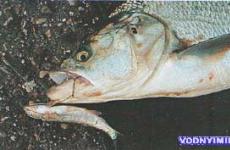
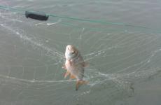
The fauna of Ireland is quite poor and if you want to look at rare animals, then you should visit the reserve. We especially visit the Killarney Nature Reserve, where animals such as red deer, wood mice, pine martens, red squirrels, badgers and foxes live. Also here you can find 141 species of birds (there are 380 species in Ireland), such as white-fronted goose, common falcon, blackbird, nightjar, chough and other species of aquatic, forest, mountain and heather birds. Fish include brown trout and arctic char. Also found here is the very rare Irish lake fish. The seas surrounding Ireland are home to herring, mackerel, cod, flounder, and sardines.
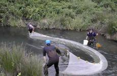
Reservoirs play an important role in the life of the country - they support the development of shipping, are used to generate hydroelectric power, and are a source of many natural resources.
In Ireland, rivers and lakes form a large network, sometimes interspersed with marshes.
Rivers do not freeze even during cold periods.
Rivers of Ireland

The Shannon is the first longest river in Ireland, its length is 368 kilometers. It extends from the western part of the country to the southeastern. The basin area is more than 15 thousand km², and the water flow is 200 m³/s.
The Shannon originates in the Kilkaf mountains, the height of the hill is small, and the source is located at an altitude of 76 meters. This convenient location allows you to clearly track the beginning of the river using navigation maps. The Shannon ends in the city-county of Limerick. The reservoir has many tributaries, the main ones being the Sak and Brosna rivers.

Barrow ranks second in length in Ireland, its length is 192 kilometers. The river originates in County Leigh in the south-east of Ireland, and its mouth is the Celtic Sea. Through the Grand Canal, Barrow is connected to the town of Efi, which is located in County Kildare.
This river is part of the so-called brotherhood of rivers in Ireland called the “Three Sisters”, besides it there are also the rivers Nore and Suir. “Three Sisters” have this name because of their graphic location - these rivers are located close to each other and all have a common mouth - the Celtic Sea.

The Blackwater is a major river in Ireland, with a length of 168 kilometers and a total basin of 3108 km². The highest point above sea level is 229 meters. This river begins in the McGillicuddy Reeks mountains in County Kerry in the south-west of the country and passes through several counties (Cork, Waterford), falling into the Celtic Sea.
The reservoir has seven tributaries, the largest of which are Allou, Obeg, Dalua and Bride. There are also settlements on the territory of the river; the following settlements are located on the banks: Mallow, Fermoy, Lismore, Youghal, Rathmore.
Lakes of Ireland

Lough Derg is one of the largest lakes in Ireland. Its coastline is 179 kilometers and its total area is 129 km². The average depth is 7.6 meters, and the greatest recorded is 24 meters.
The largest river, the Chanon, flows through Lough Derg, flowing in from the northern part and flowing out from the southern part, so the lake has an elongated oblong shape. The lake borders three counties: Galway, Clare and North Tipperary. There are several settlements along its coastline, for example Ballina, Portumna, Mountshannon. The lake is home to the amazing Holly Island, whose indigenous population is included in Ireland's World Heritage Site.

Lough Corrib is the second largest lake in Ireland with a total area of 176 km². The average depth of the lake is 5 meters, and the greatest is 10 meters.
Lough Corrib has a tributary in the form of the River Corrib, which rises directly from the lake and later flows into the Atlantic Ocean. There are also more than 300 islands in this natural reservoir.

Lough Erne is a double freshwater lake in Northern Ireland. The total area of the natural reservoir is 123 km². The highest point of the lake is located at 46 meters above sea level. The average depth reaches 3 meters, and the maximum recorded is 69 meters. Lough Erne is a navigable lake. There is a tributary - the River Erne, which flows to Donegal Bay.
According to some estimates, this body of water contains about 150 islands, according to others - at least 360. Notable places here are Devenish Island, where an ancient tower of the 12th century is located, and Boa Island, where ancient stone idols left over from the indigenous population are kept.

Lough Carra is a limestone lake with an area of 16 km². Its length, relative to other lakes in Ireland, is small - the length is 10 kilometers, and the width reaches 1.6 kilometers. The average depth of the lake is 1.8 meters, the maximum is 18 meters.
Lough Carra is located in County Mayo, which is in the West Country of Ireland. The lake is considered part of the Moore estate. There are more than 70 islands on the territory of the reservoir.
Internet version.
The island of Ireland is located at the opposite end of Europe relative to Russia, in the European west. Ireland is the twentieth largest island in the world and the third largest in Europe (after Great Britain and Iceland), it is slightly larger than the Japanese island of Hokkaido or our Sakhalin, however, it is not as elongated as Sakhalin.
Once upon a time, Ireland was not an island at all, but formed a common whole with Great Britain and the continent, but was separated from them by a sea strait (now the Irish Sea) 14 thousand years ago. The first people came to Ireland on boats from Great Britain about 4 thousand years later. The Celts, the direct ancestors of the modern Irish, appeared here later; in the Middle Ages, the Normans invaded the island, and then the British established their power, who ruled Ireland until the beginning of the 20th century. And now there are two different states here - the Republic of Ireland and Northern Ireland, which is part of the Kingdom of Great Britain and occupies a sixth of the island’s territory in the northeast.
The Irish, however, have something to brag about to the residents of the neighboring island. Thus, the Irish River Shannon is the longest (360 km) river in all the British Isles, longer than the English Thames, and any Irishman remembers this fact very well from school. At the same time, the Shannon turns out to be shorter than even our Moscow River, but do not forget that in Ireland the sea is everywhere nearby, from any point on the island it is no more than a hundred kilometers away, and the Shannon still managed to fit into this limited territory. And due to the humid climate, Irish rivers are very deep, often have powerful currents and can form large estuaries (estuaries) when they flow into the sea. A good example is the same Shannon, whose estuary stretches almost 100 kilometers in length, and 14 in width (at the point of its confluence with the Atlantic). Here the Moscow River is not even close.
Another detail that is not familiar to a resident of Russia is that the water level in the lower reaches of Irish rivers is often highly dependent on the sea tide. In the city of Limerick, located at the beginning of the Shannon Estuary, the difference in water levels in the river during the day can be more than 5 meters. Therefore, if you come to some coastal Irish city and the local river seems shallow to you - stones stick out from the bottom and mud along the shore - wait a few hours, and the river will certainly fill up. Moreover, it is not at all necessary to go to the Atlantic coast - this phenomenon can be observed right in the center of Dublin, where the difference in water levels in the Liffey River at high and low tide, depending on the phase of the moon, reaches 3.5 meters.
The same variability is characteristic of the Irish climate, although not with a 100% guarantee: rain and sun can change several times during the course. And what we call “mushroom rain”, when the Sun is visible in the sky and it is raining at the same time, is a completely ordinary phenomenon for the Irish, and they do not expect any special gifts of nature from it. At the same time, temperatures throughout the year, due to the proximity of the Atlantic, are, on the contrary, very stable; the thermometer rarely goes beyond the range from 0 to +20 degrees Celsius. This is despite the fact that Ireland is located at the latitude of our central zone: its northernmost point lies approximately on the parallel of Moscow, and the southern one - Voronezh. Snow happens here in winter, but it melts almost immediately, and +25 in summer is already hot. Although it really feels hot due to the humidity, and every couple of days it rains and drizzles. And the greatest “drought” in the entire history of meteorological observations in Ireland was recorded in the same Limerick in the spring of 1938: 37 days without rain.
There are also many lakes in Ireland. As with rivers, the largest lake in the British Isles is also located in Ireland, but this time the Northern one is Lough Neagh. In the Irish language, as well as in its related Scottish language, the word “loch” means “lake”, and even stories similar to the legend about the Scottish monster Nessie from Loch Ness exist in Ireland.
In general, the importance of water in all its manifestations in Irish life is eloquently evidenced by the fact that the names of many Irish cities carry the “water” roots of the Irish and even ancient Norse (Vikings were also once frequent guests here) languages: Cork - “ swamp”, Galway - “rocky river”, Waterford - “sheep fjord” (and not at all the English “water ford”, as you might think, although, whatever one may say, it is water). And the name of the capital - Dublin - means nothing more than “black pond”.
However, Irish nature is not limited to water alone; there is also plenty of land here: Irish rivers, lakes and swamps are surrounded by beautiful hills and mountains. There are few flat plains in Ireland, most of the terrain is hilly to one degree or another, and the typical Irish landscape is one of sheep grazing on hills that are green at any time of the year.
Not all hills in Ireland are alike; there are some very famous ones that stand out from the crowd, for example, the Rock of Cashel in County Tipperary. It is called a rock, but in fact it is a rather steep hill, standing in the middle of a more or less flat place, on which is located a whole complex of historical defensive and church buildings. It is believed that here the enlightener of Ireland, St. Patrick, baptized the king of the local kingdom of Munster in the 5th century, and at the turn of the 10th and 11th centuries, probably the most famous and powerful Irish king of all times, Brian Boru, ruled from here.
Also very historically significant and popular is the Hill of Tara in County Meath, on which the residence of the High Kings of Ireland was located.
There are real mountains in Ireland, although not as high as on the continent (the highest is Mount Carrantuil in County Kerry, 1041 m), but in some places they look quite severe.
The most beautiful mountains are located in the western part of the country near the Atlantic coast. For example, Mount Errigol in County Donegal (751 m), which locals jokingly call an extinct volcano, although in reality it looks like Mount Fuji in Japan.
In County Sligo there is a very beautiful table mountain (that is, long and flat-topped) Ben Bulben (526 m). The famous Irish poet William Yeats loved this mountain very much, and he was buried in its vicinity.
In the same Sligo there is another famous mountain - Knocknaree (327 m), on which there are several very ancient burials, including a mound made of stones of the semi-mythical Queen Medb, who lived in the 1st century BC.
And in the neighboring county of Mayo is the holy mountain of Ireland - Croagh Patrick (764 m). It is believed that Saint Patrick fasted for forty days and nights on this mountain. This mountain is a very popular climbing point in Ireland among both pilgrims and ordinary tourists.
Combining the mountain and the sea, we get a cliff. Therefore, Ireland must have many cliffs, and very picturesque ones at that. And they exist, the most famous of which are the Cliffs of Moher in County Clare, which drop vertically down into the waves of the Atlantic from a height of two hundred meters, also very famous among tourists.
Ireland is an island itself, but just as planets have satellites, there are many interesting small islands off the coast of Ireland, especially on the Atlantic side. Perhaps the most famous of them are the Aran Islands, of which there are three: Inishmore, Inishman and Inisheer. From these names it would be logical to assume that the Irish word for “island” would be “inish”, and this is true. And, by the way, these same Aran “Inishes” are one of the few places where local residents still speak in everyday life that very Celtic Irish language, which has nothing in common with English.
No less interesting, although not so well known, are the Blasket Islands, or rather, the main one is the Great Blasket Island. This island is located in the Atlantic waters off Dunmore Head, the westernmost point of Ireland in County Kerry in the very southwest of the island. There once existed a self-governing community on it, quite isolated from the outside world and the central government, like our Pomors; Many books have been written about them and by them in Ireland. But in the 1940s, all Blasketians were resettled to the Irish “mainland”. Nowadays, however, the Great Blasket can be reached by ferry during the summer.
And the highest cliffs in Ireland and again in all of the British Isles (688 meters at the highest point) are located on another island - Achille in County Mayo. Achill is also the largest of Ireland's satellite islands.
Everything in Ireland is good, but one thing is bad - there are islands around it and it itself is an island, so there is no way to get there by train. But you can take the train to the airport, and from there fly to Ireland! And on the territory of Ireland itself there is a railway, you can drive along it or along an ordinary road, and observe the Shannon River, Mount Ben Balben, fluffy sheep on the green hills and other beauties of the Emerald Isle.
1. Castle of King John (John the Landless) on the Shannon River. Limerick.
2. Cliffs of Moher, County Clare.
3. Landscape, County Clare.
4. Landscape (Hoare Abbey), County Tipperary.
5. Landscape (Lake Nakony), County Donegal.
6. Landscape (Sacred Heart Church), County Donegal.
Ireland is an island state in the North Atlantic Ocean, located on the third largest island in Europe; it is the western of the two largest British Isles. Located between 6° 20`-10° 20` W. D. and 51° 25`-55° 23` N. w. (northernmost point - Malin Head). From the east it is washed by the Irish Sea, as well as the St. George and Northern Straits, from the west, north and south - by the Atlantic Ocean. The length from west to east is about 300 km, from north to south - about 450 km. The total area is 70,280 km2. The total length of the border with Great Britain is 360 km. Coastline: 1,448 km. The highest point is Mount Carrauntoohil (1,041 m). The coasts of Ireland (especially in the north, south and west) are rocky, strongly dissected by bays, the largest of which are Galway, Shannon, Dingle and Donegal in the west, Lough Foyle in the north. There are many rocky islands off the coast of Ireland.
The surface is mostly flat, the interior areas are occupied by the vast Central Lowland, which extends to the shores of the island in the west and east. On the outskirts of the island there are low mountains (the highest point is Mount Carantuill, 1041 m) and a plateau (the largest is Antrim in the northeast).
There are many rivers (the most important is the Shannon; other large ones are the Lea, Blackwater, Suir, Nor, Erne, Bann), lakes (Lough Neagh, Lough Derne, Lough Mask and others) and swamps (in the central part). Ireland is crossed from west to east by a number of canals (Bolshoy, Royal, Ulstensky, Logansky, etc.). Warm westerly winds predominate. The climate is temperate oceanic, humid; winters are mild, summers are cool. Warm westerly winds predominate. Thanks to its mild climate, Ireland is covered in greenery all year round, which is why it has become known as the Emerald Isle.
Ireland is an evergreen emerald island with impeccable ecology and a relaxing silence of the province, with landscapes ranging from a rocky lunar landscape to green forests and mountains, lakes and even palm trees.
Relief of Ireland
Ireland consists of a low central plain and its elevated surroundings. However, both the inland plain and the coastal mountains are distinguished by significant specificity. The surface of the plain is complicated by individual hills, and in the surrounding ring of mountains there are gaps through which the plain is connected to the coast, this is especially noticeable in the area between Dublin and Dundalk on the east coast. The average height of the plain is only about 60 m above sea level.
Ireland statistics
(as of 2012)
Due to the abundance of precipitation and poor drainage, swamps are widespread there. Only 1/5 of the territory of Ireland is located at absolute heights of more than 50 m, several peaks exceed 900 m. The upper belt of mountains is represented by many short isolated ridges. Of these, only Mount Kerry in the southwest and Donegal in the northwest clearly extend from northeast to southwest, i.e. in the same direction as the mountains of Scotland and Scandinavia. Only in Donegal and Antrim do mountain ranges extend along the coast. All of them, with the exception of the volcanic Antrim Mountains, were formed in the Paleozoic. As a result of long-term denudation, the mountains of Ireland have acquired soft contours, and much of the mountain area is used for pasture. The highest point in Ireland is Mount Carrantuil (1041 m) in the McGillicuddy Reeks mountains southwest of Killarney. To the south of Dublin are the Wicklow Mountains with the highest point being Lagnakillia (924 m). The Knockmealdown Mountains rise to 795m between Waterford and Tipperary. Together with other short ridges located to the west and east, they form an elevated strip stretching from the Atlantic coast almost to the eastern coast of Ireland. The low ridge of Slieve Bloom with steep slopes, separating the counties of Offaly and Lewis, stands apart. In the county of Connemara in west Galway, Mount Tuelve Pins reaches a height of 730 m. Mount Errigal in the Derrywa Ranges in Donegal rises to 752 m.
The highest point in Northern Ireland is Mount Slieve Donard (850 m) in the Morne Mountains north of Carlingford Lough. These mountains, composed of Paleozoic granites, drop steeply to the sea. The Sperrin Mountains, located southwest of Londonderry (sometimes called Derry), reach their greatest height of 683 m (Soel). The volcanic ridge, formed in the Eocene, stretches from the Atlantic coast in the north almost to Belfast Lough. It divides the historical area of Antrim. Most of the tops of the ridge have now been leveled, and this entire area is used for pasture. In its north are the basalt pillars of the “Giant’s Causeway”. Much of the area around Armagh drains north to Lough Neagh. To the south, predominantly rugged terrain is developed.
Mount Slieve Gullion, located 5 km from the southern border of Northern Ireland, reaches a height of 575 m. The heights of this area, although massive and dissected, do not create obstacles to transport or to the penetration of the prevailing south-westerly winds, which bring moisture and moderate temperatures in the east and in the west.
The coastline in the east of Ireland is leveled and in this respect resembles the coast of England. But the western coast of Ireland is strongly dissected, which makes it similar to the shores of Scotland. The deep fjord-like bays and lochs provide excellent natural harbours. However, they are little used, except for the parking of fishing vessels located in them. Significant cities in this area are Limerick in the estuary of the river. Shannon, Galway and Sligo, each in a bay of the same name, and Tralee in Ballyheigue Cove. Many of Ireland's islands are also off the west coast. These include the Aran Islands off the coast of Donegal, Achille Island and Clare Island off the coast of Mayo and the southern Aran Islands in Galway Bay. On the south coast of Ireland, as well as on the south coast of England, there are several deep-water harbours, notably Cork and Cove, both in the Bay of Cork, and Waterford at the mouth of the Suir River. The main ports on the east coast are Dun Laoghaire on Dublin Bay, Dublin at the mouth of the Liffey River, Drogheda at the mouth of the Boyne River, Dundalk on Dundalk Bay, Newcastle on Dundrum Bay and Belfast on the Lagan River at the top of Belfast Lough. In addition to Dundrum Bay and Belfast Lough, there are two other large bays on the coast of Northern Ireland - Carlingford Lough and Strangford Lough. The main port in the north is Londonderry at the top of Lough Foyle, 5 km from Northern Ireland's border with the Irish Republic.
Water resources of Ireland
The Shannon is the largest river in the British Isles, its length is 386 km, its drainage area is 11,769 sq. km. It begins in the north-west of County Cavan and flows first south and then south-west. In the middle reaches it expands, forming the lakes Lough Ree and Lough Derg. Somewhat above Lough Ree, the Royal Canal approaches the Shannon, and between the two lakes the Grand Canal, both of which reach Dublin. In the area between Lough Derg and the mouth of the river there is a hydroelectric power station, built in 1929. The transatlantic airport Shannon is located in Rinianna near Limerick on the right bank of the Shannon Estuary. In Northern Ireland, the River Bann, starting in the Morne Mountains, flows north to the Atlantic Ocean. In its middle course is Lough Neagh. The River Bann is connected by a canal to the River Lagan and Belfast. Another channel connects Carlingford Lough with the upper reaches of the River Bann and, therefore, with Lough Neagh. This lake is the most prominent feature of the orohydrography of Northern Ireland. It is the largest in the British Isles, with an area of 396 square meters. km, the water's edge is raised only 15 m above sea level, depth 31 m. The drainage basin of the Bann River is 5960 sq. km. The river valley contains much of Northern Ireland's best agricultural land. The River Erne, starting in County Longford, flows generally northwest into Donegal Bay through Lough Outer, Upper Lough Erne and Lough Erne. Its length is about 113 km. The basin of this river includes the historical region of Fermanagh, located mainly in the central plain of Ireland. The River Leafly begins in the Wicklow Mountains and flows into Dublin Bay. The city of Dublin is at its mouth. The river is not navigable. At the mouth of the Foyle River in the north of Ireland is the city of Londonderry, at the mouth of the Lee River is the city of Cork. Other rivers flowing to the south coast of Ireland include the Suir, the Nore, the Barrow, which flows into Waterford harbour, the Blackwater, which flows into Yule Bay on the border of counties Cork and Waterford, and the Slaney, which flows into Wexford harbour. The western Connacht counties of Galway and Mayo contain several large and many small lakes. The flow from Lough Mask and Lough Corrib, which have only an underground connection, is directed south into the Galway River, and the flow from Lough Conn in Mayo is directed north along the Moy River into Killala Bay.
Climate of Ireland
The climate in Ireland is velvety, soft and even, and differs from the climate on the neighboring British island in its smaller temperature range and average rainfall. The island's proximity to the European continent, mid-latitudes, and warm Gulf Stream currents flowing off the western Atlantic coast - all this creates an even, mild, temperate climate on the island.
Moderate southwesterly winds prevail on the island, the flows of which are influenced by the powerful warm Gulf Stream current. Air currents can unexpectedly bring clouds filled with Atlantic moisture with heavy or drizzling rain at any time of the year. But just as unexpectedly, the rain may stop, and the Irish sky, combined with evergreen meadows, will open before your eyes in all its splendor of colors.
Since the size of the island is relatively small (the farthest point of land on the island is 110 km from the sea coast), the temperature throughout the island is approximately the same. But, despite the fact that the island is relatively small, in the central part of the island the influence of the marine climate is felt less noticeably than near the coast. At the same time, regardless of the time of year and weather, anywhere on the island you can feel the amazing, healing smell of the ocean, ennobled by the pure aroma of forests and green meadows.
The driest month on the island is February. But Ireland does not belong to the category of arid countries, because there are about 175 rainy days a year, and the average rainfall on the island is about 1000 mm per year. It must be remembered that the average rainfall varies between the west and east, north and south of the island. In some western counties of the island (Kerry, Mayo, Donegal) there are about 200 rainy days a year, and the average rainfall is about 1500 mm per year. This is due to the predominance of winds from the Atlantic in the western regions of the island. It is also no surprise that on some parts of the coastline of these counties the average number of rainy days reaches 270 per year, and the average rainfall is about 2000 mm per year.
According to statistics from meteorologists, the least rainy eastern Irish counties are Dublin, Meath and Kildare. Precipitation is less than 800 mm, and there are about 150 rainy days per year. The southern coast of the island has the mildest climate.
Snow falls very rarely on the island, as a rule, it is not abundant and does not last long. If it falls in such quantities that it covers the ground, it will completely melt within a few hours. In the mountains, snow falls more often, more often, and lasts longer. The average annual temperature on the island is +14°C. The coldest months are January and February. The average temperature at this time ranges from +7–14°C. The warmest period is July and August, with an average temperature of about +14–20°C, but sometimes reaching +25–27°C. Precipitation is 1200-2000 mm per year. Sea water temperature in winter is from +6°C to +10°C, in summer from +12°C to +17°C.
Ireland's most unusually low temperature of -19°C (-2°F) was recorded in January 1881 in County Tyrone. An extremely high temperature of +33°C (+91°F) was recorded in June 1887 in County Kilkenny. The heaviest rainfall in a year (3965 mm) was recorded in 1960 in the mountains of County Kerry. And the most generous precipitation within 24 hours (184 mm) was recorded in June 1963 in Dublin. The strongest gale wind (54m/sec) was recorded in 1974 in County Down.
The division into seasons in Ireland is quite arbitrary. Despite the fact that in Ireland the official calendar is the Gregorian, nevertheless, in the country it is customary to divide the seasons somewhat differently than in Europe. The year consists of summer and winter. The first of May marks the beginning of summer, the first of November marks the beginning of winter. Perhaps this tradition takes its origins from some ancient calendar.
Flora and fauna of Ireland
The flora of Ireland is similar to that found in most of Europe, but much less diverse. The Burren region in County Clare is unique, where species from the Arctic-Alpine zone, preserved from the Ice Age, coexist with Mediterranean species. Common tree species are oak, ash, birch, alder, willow, and walnut. The formerly extensive natural forests were cleared over most of the country in the 17th century. and now occupy approx. 6% of the country's territory, mainly in the center and east of the island. State policy is aimed at expanding plantings, mainly of unpretentious and fast-growing coniferous trees that take root even on peat bogs. The Wildlife Protection Act 1976 protects 68 species of native flora.
The fauna includes approximately 380 species of wild birds recorded in India; 135 nest on the territory of India. The most interesting species include the gyrfalcon and peregrine falcon, corncrake, and chough. Freshwater fish include salmon, char, whitefish, eel, and pike. Amphibians are represented by a frog, newt, and toad (1 species each). Of the reptiles, only the common lizard lives. The country is home to 31 species of mammals, including red deer, fox, badger, common squirrel, beaver, gray and harbor seals and many cetaceans.